Home > Travel > Ísland 2004
07/01 | 07/02 | 07/03 | 07/04 | 07/05 | 07/06 | 07/07 | 07/08 | 07/09 | 07/10 | 07/11 | 07/12 | 07/13 | 07/14 | 07/15
|
||
|
Home > Travel > Ísland 2004 07/01 | 07/02 | 07/03 | 07/04 | 07/05 | 07/06 | 07/07 | 07/08 | 07/09 | 07/10 | 07/11 | 07/12 | 07/13 | 07/14 | 07/15 |
||
Reykjavík - Þjórsá - Landmannalaugar Saturday, July 3, 2004
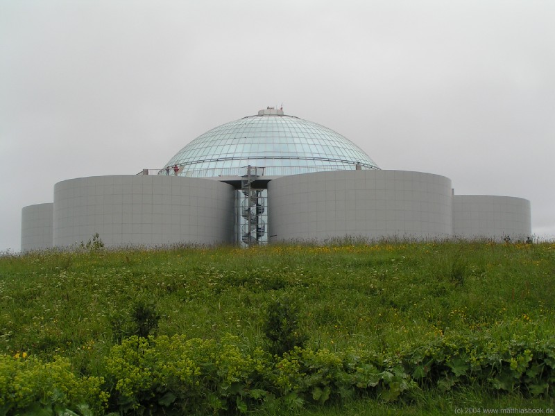
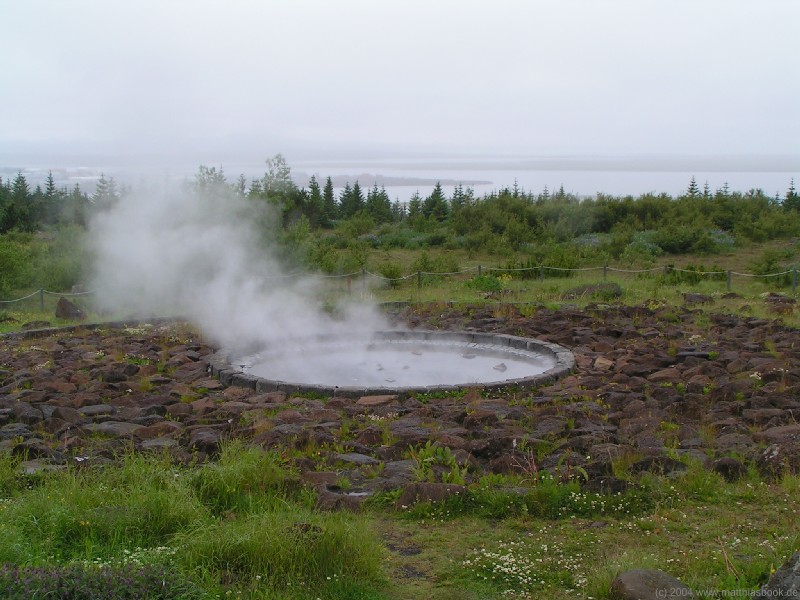
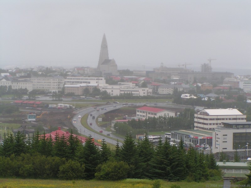
Next, we need to complete our household inventory: At the campground, we buy a camping gas cartridge with European valve (not knowing this type is hard to find, we get only one, which we're still going to regret next week), then check out and get some more groceries in a small supermarket nearby on Laugalækur. Breakfast is some more pastry in a small bakery just across the street, then we get on our way via Sundlaugavegur, Kringlumýrarbraut and Suðurhlíð to Perlan. Sitting on top of Öskjuhlíð, the Perlan hot water reservoir is Reykjavík's new futuristic landmark. Six tanks holding 18 million liters of water surround a spacious winter garden with palm trees, art exhibits, conference rooms, a restaurant and saga museum. A platform on top of the tanks offers a 360° panorama over Reykjavík and the Faxaflói bay - today, however, the city is shrouded in low-hanging rain clouds, so we rather enjoy the artificial geyser spouting inside every few minutes. Close by on the hill, the artificial Strókur geyser is supposed to look even more natural - unfortunately, it's only turned on in the afternoon.
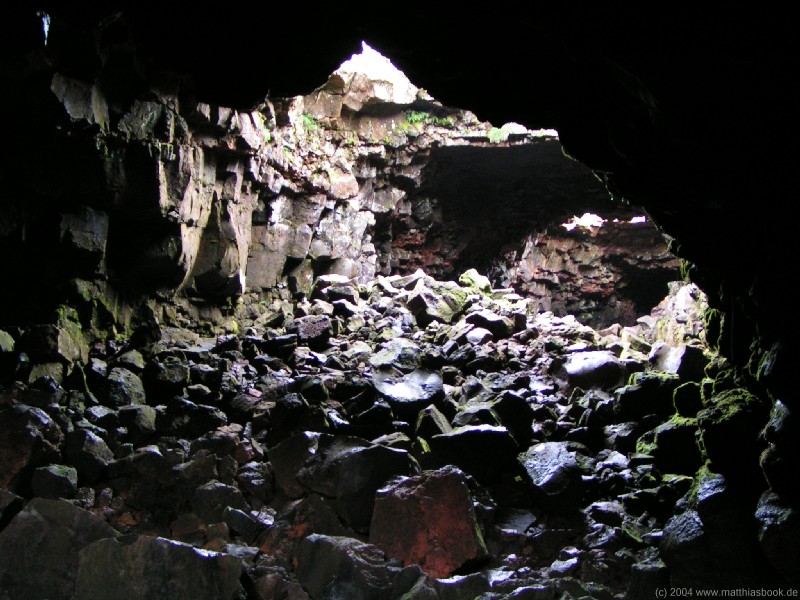
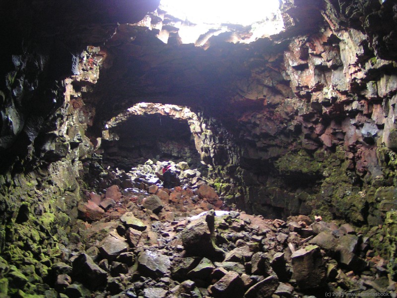
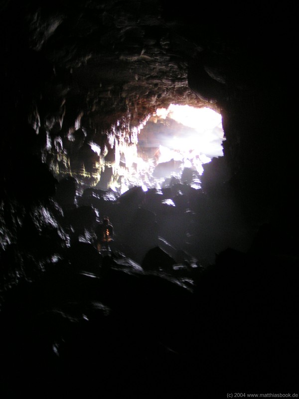
Since walking around Reykjavík in the rain doesn't sound too appealing, we decide to leave the capital behind and start our journey around the island. Should we go clockwise or counter-clockwise though? People say if it's rainy in the South, it's sunny in the North and vice versa - however, the weather forecast in a newspaper lying around on Perlan's bistro tables just predicts rain everywhere for the next few days. We're not too deterred by that - the South-West is Iceland's most humid corner, and people also say if you don't like the weather, just wait for 15 minutes and it'll get better (on the flipside, it also won't last longer than 15 minutes if you do like it). We finally decide to put off the ultimate decision for a bit longer and go east to Landmannalaugar for now, which will also give us an opportunity to practice our 4x4 driving skills before travelling deeper into the highlands. Soon, we're on Suðurlandsvegur, the part of the ring road 1 leading south-east out of Reykjavík. Since we don't want to head straight for Landmannalaugar, but take some scenic detours along the way, we turn south on road 39 about a dozen kilometers before Hveragerði. This road towards Þorlákshöfn takes us through the Eldborgarhraun lava field and to the first real adventure on our trip: About 3 km before the intersection of roads 38, 39 and 42, we stop for a visit to Raufarhólshellir, the second-longest lava cave of the country. Just equipped with flashlights, we enter through the southernmost cave-in. Slowly, we scramble down a slope of lava blocks into the mouth of the cave, peering anxiously up at the moss-covered roof that is by no means solid rock, but crumbly lava. Inside, we feel like standing in a very roughly hewn tunnel - the "floor" is a cluttered chaos of huge lava blocks, and on the ceiling there's more where those came from. The only light streams in through cave-ins along the way.
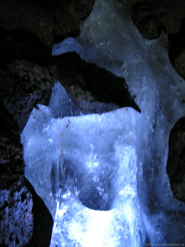
Cautiously, we pick our way over the cold, moist rocks deeper into the cave. The light fades rapidly once we move further away from the cave-ins, the air is cold and humid, and our breath condenses in little clouds. In some spots, we find small ice formations nestled between the rocks - frozen stalactites hollowed by water dripping out of the darkness above. Caves like this are formed when a semifluid lava stream solidifies on the surface while magma is still flowing underneath, leaving a tunnel behind. Raufarhólshellir is 1.350 m long and runs to a depth of 32 m, but we don't intend to venture that far - the crumbly lava is very susceptible to the strong erosive forces of wind, ice and seismic activity, so the risk of a collapse is omnipresent in Iceland's caves. When the darkness, and most of all the eerie silence, become palpable in a cavern just around the corner from the last cave-in, we turn around.
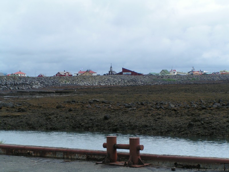
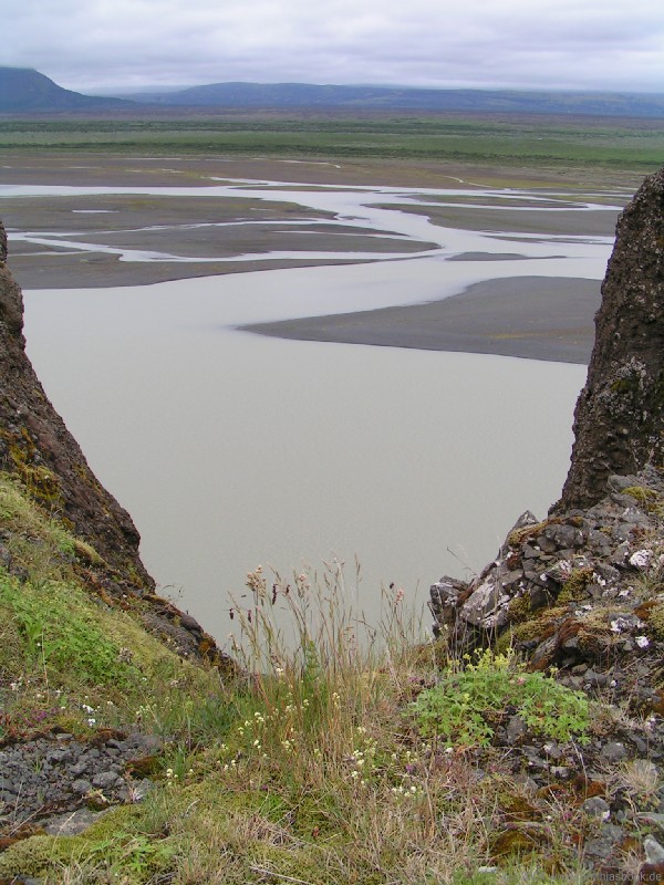
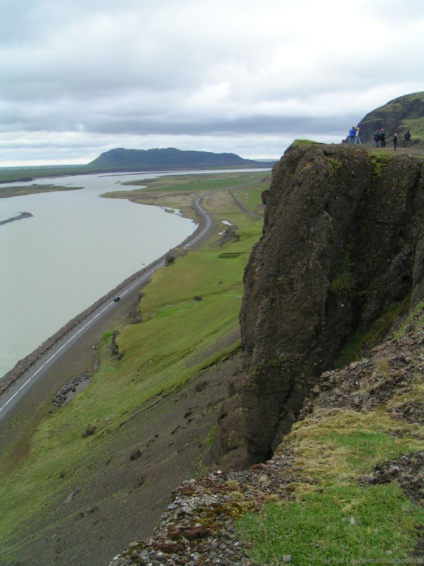
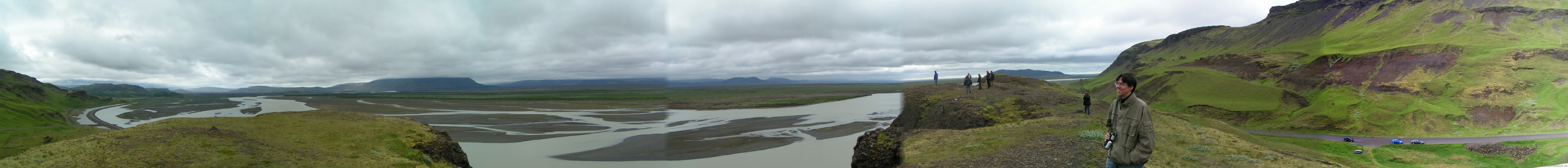
Back in daylight, the adrenaline wears off slowly. In Germany, such excursions would probably be strictly prohibited, but in Iceland, a simple sign at the cave entrance warns people that the cave is "quite difficult to explore", recommends to bring a reliable light source and wear a helmet, gloves and good shoes, asks not to litter the cave and otherwise just wishes "Good journey" - the rest is up to people's common sense. In fact, we notice on our trip that on the rare occasions when an area is really closed, it's usually for the protection of nature, not people. After this adventure, we continue south-east on roads 38 and 34. Built on a sandbank, the 34 runs between the wide mouth of the Ölfusá river and the Atlantic before skirting the village of Eyrarbakki (pop. 515). We have a lunch picnic on a pier, enjoying a brief sunny spell, then slowly drive along the village's main road before turning north-east on road 34 towards Selfoss. From Selfoss, the region's supply and service center with about 4.300 inhabitants, we head further north-east. While the scenery along roads 1 and 30 is dominated by green meadows and farmland, it gives way to less arable land as we drive further inland along the river Þjórsá on road 32. Shortly before the entrance to Þjórsárdalur, we take the old road up to the Gaukshöfði rock ledge. From the top of cliff, we have a great panoramic view over the murky waters of the wide Þjórsá (Iceland's longest river measuring 230 km) and the expanse of lava fields beyond that have flown from the infamous, quite active volcano Hekla just across the valley. Unfortunately, its almost 1.500 m high snow cap is often shrouded in low-hanging clouds, and today is no exception.
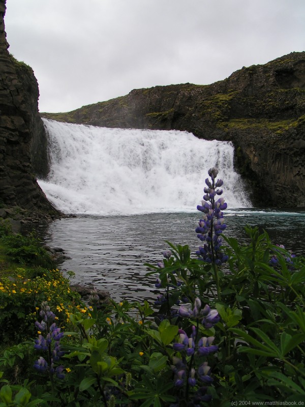
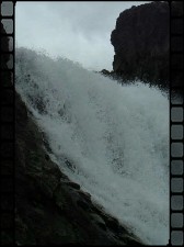
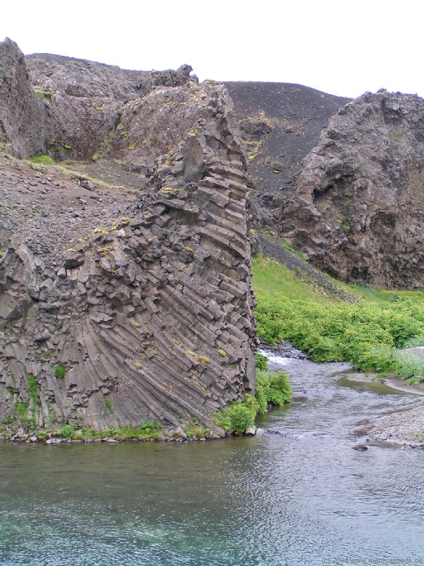
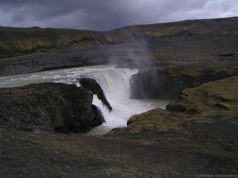
Continuing onwards on road 32, we take a short excursion to Hjálparfoss, a waterfall that is spectacular not so much because of its height, but its beautiful setting: Split by an outcropping of black rock in the middle, the symmetrical twin falls flow into a round pond framed by basalt formations, greens and flowers. Walking around the pond, we can get right up to the fall.
Shortly before road 32 crosses the Þjórsá, we turn left on a jeep track in order to reach Haifoss, Iceland's second-highest waterfall a few kilometers north-east from here. The gravel track runs along a power line (probably for maintenance purposes). After passing a sheep gate, we reach our first ford - in retrospect, not much more than a puddle formed by a small rivulet, but ever cautious, Matthias wades through to check for rocks or potholes under the surface. The water turns out to be no more than ankle-deep anywhere and no problem at all for our Jimny - later on our trip, we would just breeze through fords like this without even stopping, but hey, this is one's our first!
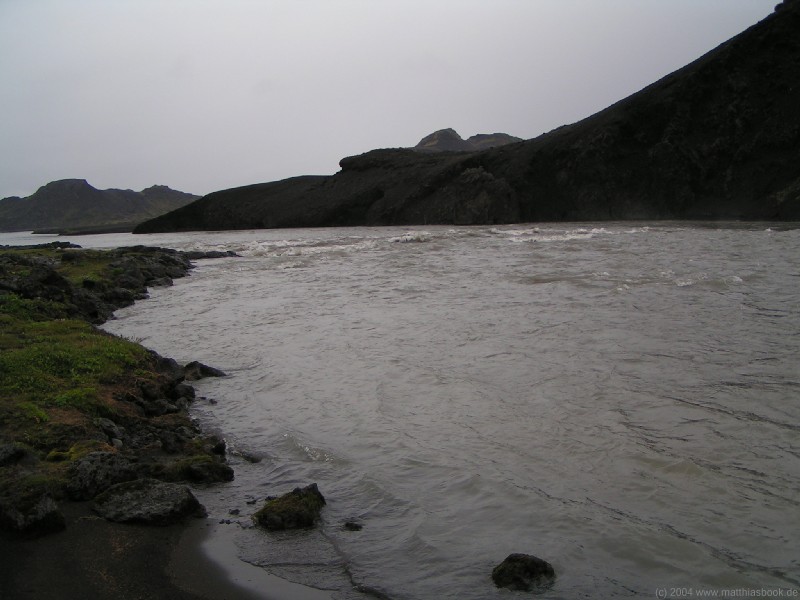
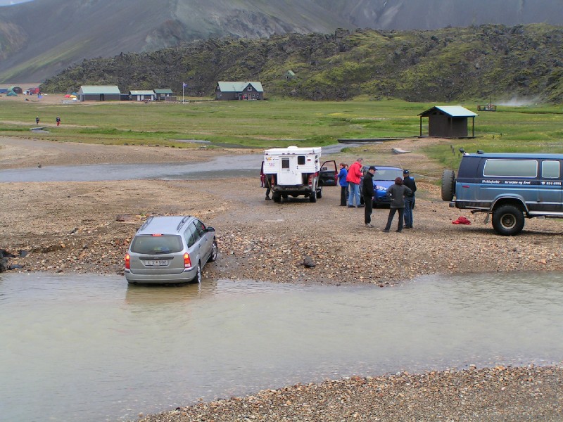
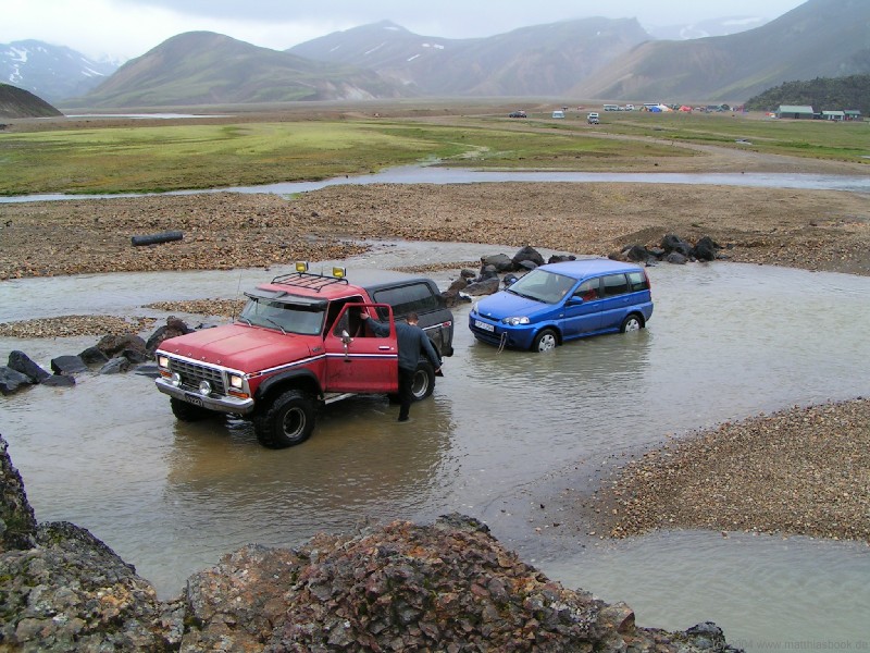
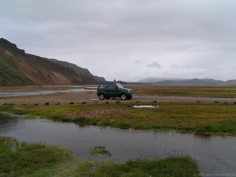
We finally reach Landmannalaugar - and our second ford of the day, which is quite a bit more challenging: The road dips down into a dammed river and emerges on the other side, where a campground and hot springs beckon. We climb up on a ridge overlooking the ford to survey the situation. Our first observation: We're actually dealing with two fords separated by a sandbank. Our second observation: On the sandbank is a compact car that is obviously dead and prepared to be towed away by a big jeep. Our third observation: All vehicles on our side of the river are compact cars, while all (functioning) vehicles on the other side are 4x4 vehicles - all bigger than our Jimny though. A highland bus arrives and plows effortlessly through the ford - no problem with 4x4 drive, tractor wheels and elevated back section! All the bus and heavy jeep traffic deepens the ford considerably though - according to our guidebook, it is up to 60 cm in the middle. This is demonstrated spectacularly when another compact car approaches - we expect it to turn into the parking lot, but the driver just hesitates briefly, then floors it and careens right into the river. Water fountains shoot up left and right, the hood dips under water, the engine dies, and the car is carried halfway up the other embankment only thanks to its own momentum. Clouds of steam rise from the hot engine and exhaust pipe as the driver tries to turn the engine over again and again. Miraculously, it starts up again after a number of long minutes, and the guy continues to breeze through the second ford! This clears the way for the first car to be towed back through the ford... at least until the rope tears in the middle. We use the waiting time to discuss our options - try our luck with the ford or stay on the safe side? On one hand, we don't want to risk our car on the second day, on the other hand, we don't want to be the only 4x4 this side of the river! After lengthy consideration of the terrain from our vantage point on the ridge, Nils finally decides to try driving right on the edge of the ford where the water should be more shallow. No risk, no fun - Nils steers steadily and determinedly close past the boulders lining the dam, the Jimny dips a little to the side, but the water never reaches above the license plate. Without stopping on the sandbank, Nils tackles the second ford in the same manner, and gets through without problems! Our confidence increases considerably as we pull up to the other big 4x4 vehicles - it would indeed have been a shame to stay with the compact cars on the other side!
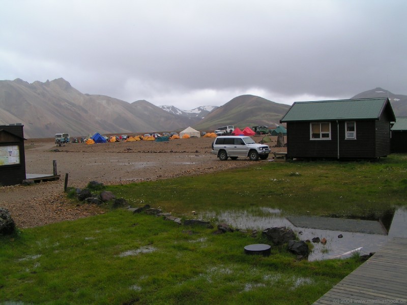
Landmannalaugar, the "hot springs of the peasants" at a height of 600 m, is somewhat of an oasis in the Fjallabak area, but a barren one: Thick clouds are hanging low over Iceland's largest rhyolith range. Mountains coloured in all shades of brown, red, orange and green enclose a wide valley of gravel plains and the murky arms of the Jökulgilskvísl. The campground is simply a large roped-off gravel area without any wind protection, except for the array of all-terrain vehicles of all shapes and sizes parked along its edge. Our Jimny is among the smallest in a row of Jeeps, trucks and even decommissioned fire engines, many of which look quite adventurous but definitely well-equipped for rough roads. We manage to find a campsite on a patch of grass at the side of the grounds. After checking in at the Landmannalaugar hut run by Ferðafélag Íslands (the Icelandic Touring Association) and affixing the camping decal to our tent, we're eager to visit the hot springs. A squishy wooden boardwalk leads away from the campground and across a green marsh to the hillside. We change on a wooden platform and then gingerly step into the knee-deep river, which is actually quite cool here. But with every step upstream, the temperature rises, and right at the foot of the hill, we find people soaking in a clear natural pool of comfortably warm water. Rivulets of steaming water are running off the hillside into the pool, and we adjust our bathing temperature by carefully scooting just close enough to the hot streams to be warmed up, but not scalded. Every now and then, the underwater currents shift momentarily, sending sudden waves of hot or cold water flowing across our backs. What a great way to experience the outdoors - not just walking through nature, but actually immersing oneself in it!
< 02/07/2004 | 04/07/2004 > |
||||||||||||||||||||||||||||||||
|
|